By Milenko Budimir
In early April of this year, I began reading John Steinbeck’s Travels with Charley, an account of his 1960 road trip from Long Island across and up the country to the West coast, and down through the deep south and back home again. One of the questions he asks himself is just how well does he know America and his fellow Americans? He answers basically ‘not that well’ and so decides to set out on this road trip to learn who they are.
It’s somewhere around that point that I heard a related question begin to form in my own head; I’ve been an Ohioan all of my life. And yet, how much of Ohio did I really know and understand? How well do I know its people? Its history? Its roots and origins? How much do I know about what is happening in this state and with its people at this moment in history?
Living in Cleveland my entire life, I am a confirmed city boy. And I’ve been to all of the state’s major cities; Columbus, Cincinnati, Dayton, Toledo, Akron, Canton, Youngstown. But what about all of the other places, the small towns and villages and townships and all of the vast areas in between?
That’s what this trip is meant to do; to correct for this lack of knowledge. To test the limits of just how much I can learn in a few days of driving around the state.
Day 1
Hardly slept at all last night. This is partly due to the late dose of caffeine I had yesterday and perhaps to anticipation, the way I used to feel when I was 12 years old and couldn’t sleep the night before our annual trip to Geauga Lake for dad’s company picnic.
I wanted to be up at 6 a.m., but I woke up somewhere around 4 a.m. and couldn’t fall back asleep. So I got ready and was out the door by 7:15 a.m.
[blocktext align=”left”]I am leaving my own personal Kansas.[/blocktext]Heading east, I exit I-76 at Rt. 14 south and head toward Salem, the first “big town” along the way. Not 50 feet from the exit is a fireworks store, and the roads have a little more dirt on them than I’m used to and the proportion of pickup trucks to sedans and small cars has spiked. I am leaving my own personal Kansas.
The morning air is crisp and the skies are a promising pale blue. Sunlight skips off the brown fields and glints off of the greening tree branches all up and down the road and across the countryside. I make my way through Salem and come to Lisbon by 9 a.m. I drive through a bit of the town (or, more likely, most of the town) and note that Marcus Alonzo Hanna (Ohio’s own 19th-century “president maker”) was born here. I also take note of the well-preserved 19th-century buildings and the vibe of small-town America that is visible from the driver’s seat, which gets invariably more complex when one scratches beneath the surface.
On the Ohio pages of my State Farm Road Atlas (which I still use because it doesn’t require batteries and I like paper objects) there is a small red square marking something called the “Morgan’s Surrender Monument” somewhere on Rt. 518 south of Lisbon near West Point. Curious, I set out to find it. After several hairpin turns through sections of road I could’ve sworn were no such thing, and just a few hundred feet before deciding that I’d gotten lost and needed to turn around, I saw on my left something that looked like an historical marker in that it looked completely out of place in the landscape.
[blocktext align=”right”]And there you have it, another reason why history is awesome.[/blocktext]The Morgan’s Surrender marker is on Rt. 518, essentially next to somebody’s small steel storage shed and a few feet from a gravel parking lot belonging to an “industrial services” company. There was a large stone, probably 8 ft high, with a plaque mounted to it that read: “This stone marks the spot where the Confederate raider Gen. John H. Morgan surrendered his command to Maj. George W. Rue July 26, 1863 and is the farthest point north ever reached by any body of Confederate troops during the Civil War.” And there you have it, another reason why history is awesome. I mean, who knew? I certainly didn’t, and I bet few people besides a handful of hardcore Civil War buffs know either. But the moment you know this fact, your world shifts ever so slightly. For a de facto Northerner like me, practically a Canadian, this small fragment of history just changes what hitherto I’d known about the Civil War. It’s like the discovery that there was a sizable POW camp for Confederate soldiers on Johnson Island hidden in a small bay off of Lake Erie just west of where Cedar Point amusement park now stands, and that there is a cemetery there with the remains of some of those soldiers who didn’t survive the war.
And so with that first stop I’m vaulted back 150 years to the world of the Civil War, imagining what this landscape looked like and what life was like back then, and the queerness of Confederate soldiers this far north in the Union.
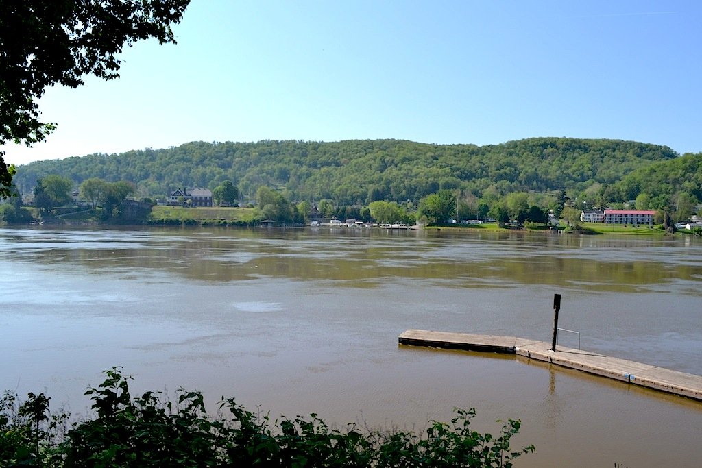
I got back on Rt. 30 and was in East Liverpool in no time. I crossed a set of railroad tracks hard by a row of enormous white storage tanks and parked by the Broadway Wharf to have a look around. I am shocked and amazed at how wide the Ohio River is at this point, and how high and close to land. There are no hilly banks of the river as it flows right up to shore. Down by the landing I see a mother and her young son feeding some geese while two feral cats in the bushes nearby study me and my intentions.I get back in the car and head up a hill toward the center of town. I had come to East Liverpool mainly to see the Museum of Ceramics. From about the mid 19th century to 1910, the city was home to a booming ceramics industry that dominated the United States, so much so that the town’s nickname is “the pottery capital of the world.” In fact, Viktor Schreckengost himself was born in nearby Sebring.
Knowing my luck, the museum is closed Mondays. So I roll down the windows as it’s getting a bit warmer and slowly drive around town to check things out. As it is, I catch a glimpse of life here; a colorful local man in a dark black cowboy hat, fishing pole and tackle box in hand, walking towards the river, whistling a happy tune on this warm spring morning, and across the street an old man carrying a large flower arrangement for a funeral to the side of a delivery van.
East Liverpool is no doubt a river town. It looks and feels like so many others I’ve visited, mostly living in the shadows of past glory. It’s heart-achingly sad amidst this beautiful day. I stop into an antiques mall and feel even sadder amid the thousands of square feet of antiques, the flotsam of people’s lives, objectified memories. I walk around a bit but just can’t handle the vibe, so I leave.
And I’m back on the road again, heading towards Steubenville. The drive along Rt. 7 is pleasant enough. The speed limit is 55, which is just about right for gazing around at the greening hills above me and the swiftly moving river below. I pass by small towns with names like Wellsville, Stratton, Toronto.I roll into Steubenville around noon. My first impression is that it looks livelier and fresher than East Liverpool, though admittedly not by much. It, too, has that patina of a bygone golden age, although there is some newer construction about town that blends in with the older, if not the completely dilapidated. Plus, it’s the hometown of Dean Martin and, apparently, Traci Lords. (Readers under a certain age, Google it.)
My first stop is the parking lot of the restored Fort Steuben. I walk into the visitors center for a look around and end up in the small bookstore where I pick up a copy of “12 Years a Slave” by Solomon Northup. I wander the grounds a bit and head to the recommended Naples Spaghetti House to have lunch. The place still has that mom-and-pop restaurant charm in that it’s entirely unpretentious, homey and comfortable. There’s a mix of old ladies and young blue-collar workers. I get a small salad and a “meatball heel,” which is half of a loaf of Italian bread with the soft part hollowed out and filled with a meatball and sauce. It’s a lot of bread, too much really, and only one little meatball. The entire meal is 10 bucks, so the budgeting part of my brain is happy.
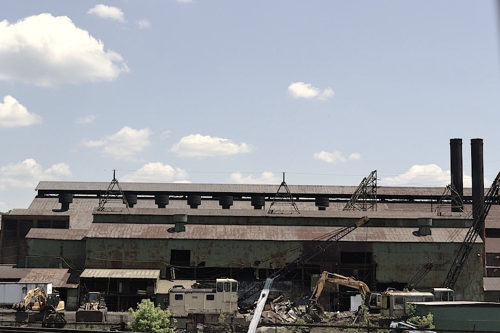
Left Steubenville and drove a few miles south to Mingo Junction. I parked next to some railroad tracks (they are everywhere here along the river) where I had a clear view of the ongoing demolition of the steel mills directly in front of me. Noisy yellow claws moved about, grabbing and pinching at the green steel walls, pulling them down and crushing them up. In the air is the sweet pungent smell of burning coal and not too far down the road I see a still active mill with a plume of orange flame flitting atop a blackened steel stack.Driving south towards Martins Ferry, I pass more small towns: Brilliant, Rayland, Tiltonsville, Yorkville. Rayland is fairly representative; a long band of steel mills along the river with houses and a football stadium in the foreground.
And just like that I’m in Martins Ferry, hometown of legendary Brown’s player Lou “The Toe” Groza, and the poet James Wright, who immortalized the town in his poem “Autumn Comes to Martins Ferry, Ohio.” I take a few photos in town, then drive the industrial wasteland by the river.I stop at a Kroger in Bellaire to see what I can buy. I use the bathroom and buy a small bottle of green tea, lightly sweetened with honey. On the way out, I see a sign that says “Now Hiring Service Super Stars!”
A quick search on my phone reveals there may be some hotel options over the river in West Virginia at a place called Moundsville. So I check out one motel, which is all booked up, but the nice lady suggests a few more options up the road on Rt. 2. I find the Sleep Inn behind the Walmart (just as she described it) and get a room for the night.
Day 2
I stop into the Walmart next door to pick up provisions, which turns out to be nothing more than a bottle of water which would probably last all day. The Moundsville Walmart is peaceful and quiet at 8:30 on a Tuesday morning, with the day’s commerce just beginning to stir. A bit further down the road I put $30 of gas in the tank at an Exxon and notice the little things; that most of the cars on the road or in parking lots are noisy (which means they are old and in need of repair and their owners most likely don’t have the means to buy a new one, so they patch it and keep their fingers crossed); that there are a lot (a lot) of pickup trucks on the road and parked in lots all over town; a lot of people smoke, too; and when I went to wash the windshield I found a can of Kodiak in the washer basin; there’s a lot of rough, curt talk, too. The places I’ve seen here are not tourist packed but filled with the real people of the land. The survivors. Like the woman who pulled up behind me and is in and out quicker than I am, which only means one thing; she’s put enough gas in to keep the car moving, just enough.
At 9 a.m. I cross back into Ohio and notice that the river barge traffic has picked up as well. I soon come to Powhatan Point, where a sign tells me that George Washington camped here.
As I continue down Rt. 7 a subtle truth comes to me, though it really isn’t very subtle at all but merely that I’ve missed it. There are a lot of power plants up and down the river. And the barges moving up and down the river invariably are hauling coal. There are so many, in fact, that this could easily be nicknamed the Valley of Power.
Not long after, I pass a natural gas plant of some kind. The most prominent feature, which can be seen for miles away, is a tall (I’m guessing 100 feet or so) pole with what appear to be a series of 5 or 10 individual burners all flaring off gas with a bright orange flame.
Another odd thing you see here a lot are pipes coming out of the ground, then plunging back in; under paved roadways and up and out again, snaking off into the woods and back underground again.
I pass through Sardis, which looks like it’s doing OK, relative to other shabby river towns. And I wonder why some places do well while others don’t.
Nearing Marietta, I switched on the radio hoping to catch some local flavor. And boy, do I. There’s an old guy, 91 years old, interviewing a younger guy, some author, about the Bible and the end of the world and trials and tribulations, and those kinds of things. I can’t believe what this guy is saying, all kinds of made-up hokum about the number 666 and the Old Testament and the book of Joshua and the number of trumpets in the Book of Revelation, and on and on and on. I just couldn’t believe that any person could get so lost in such a bizarre mental cul-de-sac and say the most ridiculous things over the radio. But there it was. Unfortunately, the reception was bad so their conversation kept getting spottier until I just had to give up and shut the radio off. How disappointing.
I rolled into Marietta at 10:30. I had been in the city years ago and even though it was relatively brief, I don’t remember it being this built up back then. Coming in from the east on Rt. 7 there are new mega strip malls lining both sides of the road; Krogers, Lowes, big-box this and that, with all the attendant traffic problems.
The old downtown is still beautiful, though. And it, too, has changed over the years, but for the better. I see an Indian restaurant and even a hookah bar.
I park near the river and plot my next move, which is to head towards Athens and points west. As I drove, it occurred to me that Marietta is the perfect “last stop” on my Ohio River driving tour since it’s probably the biggest and most charming city of them all, next to Cincinnati.
I got to Athens shortly after noon. What a charming, pretty little college town with a lot of active energy around. I parked at a meter and walked around downtown for a bit. I went to a bookstore (naturally) and walked out with Rousseau’s “Discourse on the Origin of Inequality.” I then had some lunch at a place called Habibi’s; a crispy Greek salad and hummus and pita chips while reading the local Athens newspaper.
Out of Athens I set out on Rt. 50 headed toward Chillicothe. Driving on the edges of the Wayne National Forest, I marvel at the density and sheer vastness of the woods. It is one of the thickest I’ve ever seen. And I imagine what it looked like hundreds of years ago when, according to an old legend, a squirrel could travel from the Ohio River to Lake Erie by hopping from tree to tree without ever touching the ground.
Not far down the road near the Vinton/Ross county line, I see an old man on a lawn chair in front of his garage burning something in a 55-gallon drum nearby. He waves to me as I speed by at 55mph.
Finally, around 4 o’clock, I make it to Chillicothe. A sign as you enter the town reads “Ohio’s First Capital.” I drove through the well-preserved town center, ogling the old buildings with their sturdy stone and the ornamentation on the Victorian mansions still standing.
I found a room near Rt. 23 at an America’s Best Value Inn for $68 (tax included), which I paid for in cash. (Plus a weird $20 deposit. My hunch is that a lot of people forget about the deposit and so they get an extra $20 here and there. But that won’t happen with me.)
As soon as I walked into the office I was overwhelmed by the scent of curry. A young Indian guy booked my room for me. I asked him about nearby restaurants, mentioning that I’d noticed the curry in the hopes of there being an Indian place nearby. “No, I’m afraid not,” he says, but he did point me toward Bridge Street and told me I could find practically anything I wanted there. And he was right. I found Bangkok Palace, which one would assume is a Thai restaurant. In fact, it happens to serve 95% Chinese dishes with a small 5% smattering of Thai dishes, with Pad Thai being the obvious one.
In Chillicothe, I notice that the Kroger has a Starbucks inside of it. And I wonder about how relative criticisms of such corporate entities really are and how this may help explain some of the red state/blue state thinking. For instance, in a big city like Cleveland or others, people are apt to groan when they see yet another Starbucks opening up somewhere, perhaps making it tough for a mom and pop to stay open. Call it saturation. But then, you look at smaller towns like Chillicothe or even smaller places and I bet the people in those places would love to have a Starbucks in their town. They may in fact be begging for one to open. Why? Perhaps the “new” factor. The being-on-the-map factor. The “we exist” factor. A positive in an otherwise bleak landscape.
Day 3
Today I begin the move away from the Ohio river experience and the hilly, forested central Ohio to the freeway-laden western part of the state, the flatter Midwestern non-Appalachian part, and make my way north toward the lake. Driving through Ohio you can’t help but be gently nudged back into the country’s history; the deep, thick forests and hilly southeast, the Indian names of towns and rivers, the forts built as outposts at the beginning of a wide frontier, the push to the west, the settlement and building of canals to spur commerce and move goods. America in all of its essence as an engine of commerce is right there, present at the inception.
I was gassed up and on the road by 8 a.m.
Driving northwest on 35 out of Chillicothe, the land gets noticeably flatter in a hurry. Gone are the dense forests of southeastern Ohio, giving way to fertile farmland stretching into the horizon. And while the traffic on 35 is modest, I realize that soon I will join the great herds of travelers on the infernal interstate. I would be connecting with I-71 south headed toward Mason to meet up with my friend Alicia for coffee at Winans in Maineville.
I get to Winans around 9:30, get a cup of coffee, and park myself at a table outside in the shade. Alicia shows up not too long after that and we have a great two-hour coffee “meeting” — honestly it is good to see a familiar face after a few days of anonymous travel.
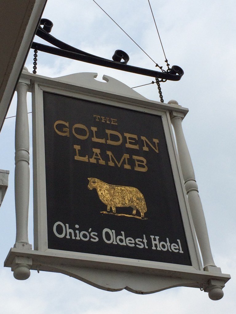
We part ways around noon and I head west looking for I-75 north. I take Rt. 48 north towards 75 and pass through the town of Lebanon, which looks interesting and charming and all that, so I park the car and decide to have a look around. The downtown area is clean with very well-preserved buildings with ample historical markers. I see a sign for The Golden Lamb, billing itself as “Ohio’s Oldest Hotel” (since 1803). There’s a lunch menu out front, so I decide to stay. The hostess placed me at a table near the window so I could gaze out on the sidewalk of the main street.What I also noticed driving north from Maineville (and even before that, actually) was how the towns all get “richer” as you move away from the southeastern part of the state. I mean there is a world of difference between some place like Steubenville or Martins Ferry, or even Wheeling and Moundsville, WV, and even Chillicothe and places west. They are more prosperous, sometimes marginally so, but prosperous nonetheless. Plus, for a place like Lebanon, being on the Cincinnati-Dayton axis doesn’t hurt either, nor does being wedged between two interstate highways. The contrast with the river towns is stark.
But it isn’t as if these areas are squeaky clean either. On the relatively short drive from Lebanon to I-75 I passed three prisons. I’m talking big facilities, not small squat buildings. Facilities so large that I wondered what factory or plant that was up ahead, only realizing when I got closer what they really were. When you look at the enormous amount of land such complexes take up, and the resources needed to build and maintain them, and the workers and staff working around the clock, not to mention the country’s growing prison population and the source of cheap — almost slave — labor they provide for corporations big and small, it’s little wonder the phrase “prison-industrial complex” is so apt.
I was on 75 north at 1:30, heading toward Wapakoneta. I briefly tune into the radio, to reconnect with the external world, since I’m not in my usual daily routine. And it feels good; both not being in that daily routine and checking back in on the status of the wider world.
About 7 miles outside of Wapakoneta, I enter the Lake Erie watershed, and I am now firmly back under the influence of the mighty lake.
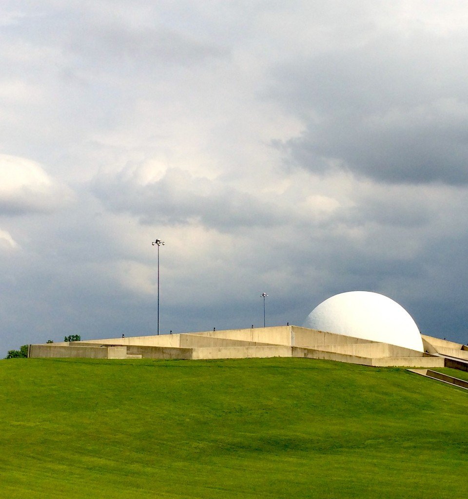
At Wapakoneta, hometown of Neil Armstrong, I get off the freeway and follow the sign for the Armstrong Air and Space Museum. Which doesn’t take long as just under the freeway off to the right is a sign with an arrow showing the way. And sure enough, there it is, just off the freeway, with its large white dome sticking out of the hilly ground, looking as if it were an organic outgrowth of the farmland surrounding it.The museum opened in 1972, only 3 short years after the Apollo 11 mission. The architecture is classical ‘70s brutalism — heavy on the concrete and also situated almost entirely underground. The design is said to have been inspired by what a future moon colony could look like.
[blocktext align=”left”]…the only one of its kind I’d ever seen in all of my museum travels.[/blocktext]Once inside, I pay the modest $8 admission and toured the humble and perfectly scaled museum. What I like about it is that it isn’t overwhelming but judicious in what it presents and how. Clearly some of the displays are in need of repair or upgrading, but overall it isn’t a problem. There are quite a few genuine artifacts, not replicas, such as the Gemini VIII capsule and a number of Armstrong’s space suits, along with vintage food rations from the ‘60s and ‘70s. There is even a section that explains exactly how astronauts urinate and defecate in space, the only one of its kind I’d ever seen in all of my museum travels. Two things were becoming apparent to me as I walked around the museum. One was that to be an astronaut back in those days of largely unproven technologies and structures meant that you had to either have nerves of steel and/or the courage of a wild animal and/or place your trust completely in the hands of the engineers designing and building these systems. The other is that you had to have been at least a little out of your mind.
The other thing I realized is how much of the technology that we all take for granted today, which is really so common as to be banal, was being used 45+ years ago by the space program. Things like new materials and communications (Audio and video from the moon … from the FUCKING moon, to earth! In 1969!) at least. And also how much space technology was subsequently commercialized.
Day 4
I hit the road bound for Toledo at 8:15 a.m.
The morning is as perfect as mornings come. A pleasant spring morning with a temperature around 60 degrees with no humidity and nothing but clear blue skies overhead. Sunlight shimmers on budding leaves at edges of brown fields on both sides of the highway. Traffic moves freely and aside from a few construction areas where speed limits dipped to 55, it is smooth sailing.
With the radio off I let my mind drift to think of either nothing at all or whatever random thoughts welled up from within. One thing that is obvious from this trip is how transportation affects a place’s prosperity. I thought this as I was driving through Lima and toward Findlay, specifically how interstates are the canals and railroads of the present age. This isn’t new or original to me. It’s been known for hundreds of years. It’s well documented what impact a canal had on a city or town’s prosperity. Even more interesting is how railroads could displace a canal town’s importance based on where a depot or station was built.
This truth is abundantly clear driving up I-75, from Cincinnati on the Ohio River through Lebanon and Dayton and up through Lima, Findlay and into Toledo and still further to Detroit. You can argue that these places are not teeming metropolises and that they are part of the “rust belt” decline, but compared with the towns along the Ohio River I visited, they are teeming metropolises.
Getting closer to Toledo, near the 475 split, off to the right there is a huge mosque with two bright white minarets piercing the sky. This is proof that I am not in rural Ohio anymore.
I roll into Toledo around 9:30. I drive down Front St. to an old power plant. Turns out the entire plant has been demolished, everything except three smokestacks that are probably over 100 ft tall, the whole thing looking not unlike some ancient Greek or Roman temple.I continue north, determined to stay as close to the water as possible. I follow the water closely, with the road eventually curving to the right and appearing to follow the lake shore. I drive through a section of town called Oregon on the Bay and Harbor View. The most stunning thing I see here is a house that certainly looks occupied not 50 feet from a huge industrial conveyor of some kind, either for coal or gravel, I can’t tell which.
Harbor View is sandwiched between the Bay Shore coal-fired power plant and a candy store of chemical plants with conveyors, pipes, and petroleum smells everywhere. How does this happen, I wonder? How and why does it persist?
From here it isn’t all that far to Maumee Bay State Park.
I see a sign for a nature center and decide to check that out. And I’m so glad I did. The Trautman Nature Center is a small building with plenty inside, including a lab area with snakes, turtles and an owl, stuffed animals, and a lot of history and scientific information on ecosystems and the animals in them.
Outside the nature center there is a maze of trails that beckon. I take the smaller loop trail and make a mental note to come back and do the longer ones in the future. I see several species of birds, particularly the red-winged blackbirds, purple martins, and crows, at least two species of turtles, and I watched a deer step gingerly through the watery marsh. At one point it came within 10 feet of where I stood on the wooden walkway atop the marsh. I stand still, careful not to make any sudden moves to startle it. We look at each other for probably 30 seconds or so, two creatures intently curious about one another. It’s magical. And then, it slowly turns and walks over to some shrubs and green leaves and began biting at them, tearing them off the branches. I point out the deer to an older guy walking toward me with binoculars. He marvels at how many deer there are in Ohio these days, mentioning that when he was a kid, all the boys his age would get guns for their birthdays and they would go deer hunting. But they’d have to go to Pennsylvania because there weren’t any deer in Ohio.
This wetland highlights the draining of the Great Black Swamp which covered a large area stretching from Toledo to Fort Wayne, IN, and down past Lima. It had existed for tens of thousands of years and was only drained in earnest from about the 1870s until 1920 or so. Humans versus nature. The agricultural imperative versus the swamp. It’s almost no contest.
Late in the afternoon I’m on Rt. 2 heading back to Cleveland, going home.
[blocktext align=”right”]Four days and 750+ miles of Ohio roadway taught me a few things about my home state.[/blocktext] Four days and 750+ miles of Ohio roadway taught me a few things about my home state. For one, its inescapable complexity; grappling with wrapping my head around a state of 11+ million people whose economic livelihoods differ so dramatically from the river towns to the Lake Erie ports and old industrial belts to the farming land and forested midriff of the state.
Through wide swaths of rural Ohio it’s easy to see the contrasts with the big metropolitan areas. The rural life, with its wide-open spaces and stunning aesthetic beauty, side by side with a persistent grinding poverty with only glimmers of hope here and there.
And still, people go on. The farmers and dwindling steel workers, the oil and gas explorers, grocery store clerks, truck drivers, waitresses and cooks. Surviving in the beautiful ruins.
Milenko Budimir is a technical writer and editor and an adjunct philosophy professor in the Cleveland area.
Support paywall free, independent Rust Belt journalism — and become part of a growing community — by becoming a member of Belt.




I so enjoyed this article. I believe it could have been written about small towns in Michigan, as you drive beyond the Detroit suburbs in any direction or about towns in Illinois, as you drive south of I-80.. Thank you.
I very much enjoyed your article, sadly you are correct about the areas around Steubenville and Martins Ferry (I live in Brilliant myself). I actually travel a lot for work and so I get a feel for other areas and I also take vacations to different areas of the country to take in their culture. To my dismay my own area is very much stuck in the past. As you noticed in Mingo the demolition of the steel mills is currently going on (actually nearly complete now) and yet people locally are still in total denial about it. While sitting at a fast food place in Steubenville I heard two gentleman talking about how rough it has been the last 10 years or so and finish his statement with “but hopefully these mills will be up and running again soon”. I was completely astounded. The mills have not only shut down but are being torn down and these men are still counting on them to reopen. I myself was raised to think these mills would always be here but it became very clear as I entered my teens that they were in decline so I studied technology and eventually ended up working in the casino industry. Each day I think about what can be done for this area. I do believe with some outside of the box thinking and old fashioned determination combined with the right kind of backers that this area could once again be economically sound. It may not have the same strength as in the days of the industrial revolution but I do believe economic stability here is possible.